


KCOD - Yellowstone Rgnl
Located in Cody, United States
ICAO - COD, IATA - COD
Data provided by AirmateGeneral information
Coordinates: N44°31'13" W109°1'26"
Elevation is 5102 feet MSL.
Magnetic variation is 11° East View others Airports in Wyoming
Operational data
Special qualification required
Current time UTC:
Current local time:
Weather
METAR: KCOD 281056Z AUTO 00000KT 10SM OVC080 06/01 A2988 RMK AO2 SLP104 T00560011
TAF: KCOD 280523Z 2806/2906 18006KT P6SM SCT080 FM281300 36010KT P6SM SCT030 OVC060 FM281700 36012KT P6SM SCT020 OVC050 PROB30 2817/2820 -SHRA BKN020 OVC040 FM290400 20007KT P6SM BKN100
Communications frequencies: [VIEW]
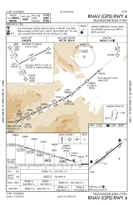
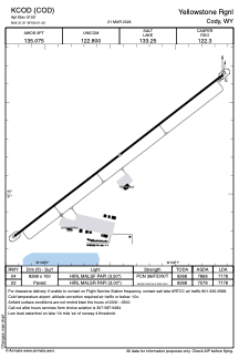
Runways:
| RWY identifier | QFU | Length (ft) | Width (ft) | Surface | LDA (ft) |
| 04 | 52° | 8268 | 100 | ASPH | 7178 |
| 22 | 232° | 8268 | 100 | ASPH | 7178 |
Airport contact information
Address: Cody United States
