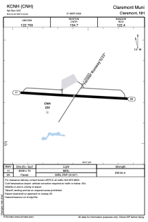


KCNH - Claremont Muni
Located in Claremont, United States
ICAO - CNH, IATA - CNH
Data provided by AirmateGeneral information
Coordinates: N43°22'14" W72°22'6"
Elevation is 543 feet MSL.
Magnetic variation is -16° East View others Airports in New Hampshire
Operational data
Special qualification required
Current time UTC:
Current local time:
Weather at : KVSF - Hartness State (Springfield) ( 12 km )
METAR: KVSF 050754Z AUTO 15004KT 10SM OVC018 09/05 A3031 RMK AO2 SLP265 T00940050
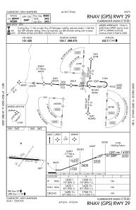
Communications frequencies: [VIEW]
Runways:
| RWY identifier | QFU | Length (ft) | Width (ft) | Surface | LDA (ft) |
| 11 | 93° | 3098 | 75 | ASPH | |
| 29 | 273° | 3098 | 75 | ASPH |
Airport contact information
Address: Claremont United States