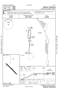
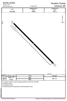


KCHU - Houston County
Located in Caledonia, United States
ICAO - CHU, IATA -
Data provided by AirmateGeneral information
Coordinates: N43°35'47" W91°30'14"
Elevation is 1179 feet MSL.
Magnetic variation is 01° East View others Airports in Minnesota
Operational data
Special qualification required
Current time UTC:
Current local time:
Weather at : KLSE - La Crosse Rgnl ( 37 km )
METAR: KLSE 270253Z AUTO 13008KT 9SM OVC013 11/08 A2968 RMK AO2 RAB16E29 SLP052 P0000 60000 T01060083 58010
TAF: KLSE 262331Z 2700/2724 13017G28KT P6SM VCSH OVC015 FM270200 13015G26KT P6SM OVC009 FM270600 16016G25KT 4SM -SHRA BR VCTS OVC015CB FM271200 21016G26KT P6SM BKN025 FM271800 23013G21KT P6SM BKN035
Communications frequencies: [VIEW]
Runways:
| RWY identifier | QFU | Length (ft) | Width (ft) | Surface | LDA (ft) |
| 13 | 135° | 3499 | 77 | ASPH | |
| 31 | 315° | 3499 | 77 | ASPH |
Airport contact information
Address: Caledonia United States