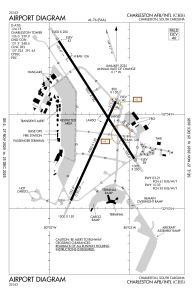


KCHS - Charleston Afb/Intl
Located in Charleston, United States
ICAO - CHS, IATA - CHS
Data provided by AirmateGeneral information
Coordinates: N32°53'55" W80°2'26"
Elevation is 46 feet MSL.
Magnetic variation is -07° East View others Airports in South Carolina
Operational data
Special qualification required
Current time UTC:
Current local time:
Weather
METAR: KCHS 270256Z 05005KT 10SM FEW250 18/14 A3032 RMK AO2 SLP265 T01780139 51007
TAF: KCHS 262329Z 2700/2724 10009KT P6SM SCT100 BKN200 FM270600 07005KT P6SM FEW015 SCT100 FM271400 12011KT P6SM SCT040 SCT200 FM271800 14013G20KT P6SM SCT045
Communications frequencies: [VIEW]
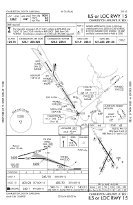
Runways:
| RWY identifier | QFU | Length (ft) | Width (ft) | Surface | LDA (ft) |
| 03 | 24° | 7000 | 150 | CONC | |
| 21 | 204° | 7000 | 150 | CONC | |
| 15 | 147° | 9001 | 150 | CONC | |
| 33 | 327° | 9001 | 150 | CONC |
Airport contact information
Address: Charleston United States
Other aviation service providers
Flight schools

Craft Flight Training & Simulation
Craft Flight Training & Simulation
craft@craftchs.com+1(843)696-9696