


KCHO - Charlottesville-Albemarle
Located in Charlottesville, United States
ICAO - CHO, IATA - CHO
Data provided by AirmateGeneral information
Coordinates: N38°8'23" W78°27'8"
Elevation is 640 feet MSL.
Magnetic variation is -08° East View others Airports in Virginia
Operational data
Special qualification required
Current time UTC:
Current local time:
Weather
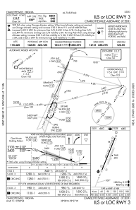
METAR: KCHO 281253Z 00000KT 10SM CLR 19/13 A3020 RMK AO2 SLP224 T01890133
TAF: KCHO 281129Z 2812/2912 18005KT P6SM SKC FM281700 19008KT P6SM SCT050 SCT250 FM290000 21002KT P6SM FEW250
Communications frequencies: [VIEW]
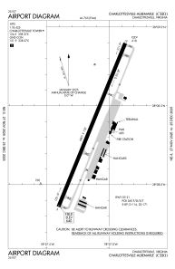
Runways:
| RWY identifier | QFU | Length (ft) | Width (ft) | Surface | LDA (ft) |
| 03 | 22° | 6801 | 150 | ASPH | 6801 |
| 21 | 202° | 6801 | 150 | ASPH | 6801 |
Airport contact information
Address: Charlottesville United States
