


KCGI - Cape Girardeau Rgnl
Located in Cape Girardeau, United States
ICAO - CGI, IATA - CGI
Data provided by AirmateGeneral information
Coordinates: N37°13'31" W89°34'15"
Elevation is 341 feet MSL.
Magnetic variation is -02° East View others Airports in Missouri
Operational data
Special qualification required
Current time UTC:
Current local time:
Weather
METAR: KCGI 281053Z AUTO 17008KT 10SM CLR 19/16 A2998 RMK AO2 SLP149 T01940161
TAF: KCGI 281120Z 2812/2912 18013KT P6SM BKN250 WS020/19040KT FM281400 18016G31KT P6SM SCT060 FM282000 19014G24KT P6SM SCT060 FM290600 19014G24KT 6SM -TSRA OVC035CB FM290900 20012G20KT P6SM -SHRA OVC025
Communications frequencies: [VIEW]
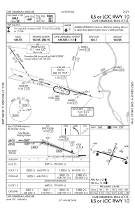
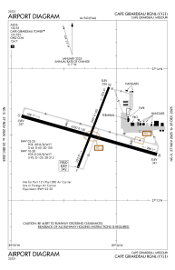
Runways:
| RWY identifier | QFU | Length (ft) | Width (ft) | Surface | LDA (ft) |
| 02 | 21° | 3997 | 100 | OTHER | 3996 |
| 20 | 201° | 3997 | 100 | OTHER | 3996 |
| 10 | 106° | 6500 | 150 | CONC | 6499 |
| 28 | 286° | 6500 | 150 | CONC | 6499 |
Airport contact information
Address: Cape Girardeau United States

