


KCEZ - Cortez Muni
Located in Cortez, United States
ICAO - CEZ, IATA - CEZ
Data provided by AirmateGeneral information
Coordinates: N37°18'11" W108°37'41"
Elevation is 5917 feet MSL.
Magnetic variation is 12° East View others Airports in Colorado
Operational data
Special qualification required
Current time UTC:
Current local time:
Weather
METAR: KCEZ 261453Z AUTO 06004KT 10SM FEW095 11/02 A2985 RMK AO2 SLP073 T01060017 58001
Communications frequencies: [VIEW]
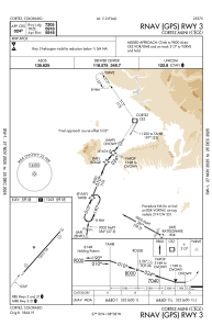
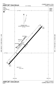
Runways:
| RWY identifier | QFU | Length (ft) | Width (ft) | Surface | LDA (ft) |
| 03 | 42° | 7205 | 100 | ASPH | 7205 |
| 21 | 222° | 7205 | 100 | ASPH | 7205 |
Airport contact information
Address: Cortez United States