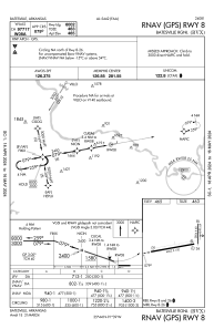
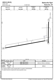


KBVX - Batesville Rgnl
Located in Batesville, United States
ICAO - BVX, IATA - BVX
Data provided by AirmateGeneral information
Coordinates: N35°43'34" W91°38'51"
Elevation is 465 feet MSL.
Magnetic variation is 01° East View others Airports in Arkansas
Operational data
Special qualification required
Current time UTC:
Current local time:
Weather
METAR: KBVX 261756Z AUTO 17005G14KT 10SM OVC027 23/18 A2991 RMK AO2 SLP125 T02330183 10233 20117 58007
Communications frequencies: [VIEW]
Runways:
| RWY identifier | QFU | Length (ft) | Width (ft) | Surface | LDA (ft) |
| 08 | 80° | 6002 | 150 | ASPH | |
| 26 | 260° | 6002 | 150 | ASPH | |
| 18 | 181° | 2804 | 60 | ASPH | |
| 36 | 1° | 2804 | 60 | ASPH |
Airport contact information
Address: Batesville United States