


KBTV - Patrick Leahy Burlington Intl
Located in Burlington, United States
ICAO - BTV, IATA - BTV
Data provided by AirmateGeneral information
Coordinates: N44°28'19" W73°9'12"
Elevation is 334 feet MSL.
Magnetic variation is -15° East View others Airports in Vermont
Operational data
Special qualification required
Current time UTC:
Current local time:
Weather
METAR: KBTV 051354Z 18009KT 6SM RA BR BKN050 OVC065 10/08 A3016 RMK AO2 SLP213 P0009 T01000083
TAF: KBTV 051325Z 0513/0612 17011G17KT 6SM -RA BR SCT012 OVC045 TEMPO 0513/0515 4SM -RA BR BKN012 FM051500 17012G21KT 6SM -RA OVC027 FM060200 18008KT P6SM VCSH BKN015
Communications frequencies: [VIEW]
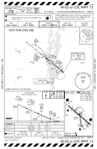
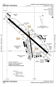
Runways:
| RWY identifier | QFU | Length (ft) | Width (ft) | Surface | LDA (ft) |
| 01 | 351° | 4112 | 75 | ASPH | 3386 |
| 19 | 171° | 4112 | 75 | ASPH | 3386 |
| 15 | 131° | 8319 | 150 | OTHER | 7820 |
| 33 | 311° | 8319 | 150 | OTHER | 7820 |
Airport contact information
Address: Burlington United States
