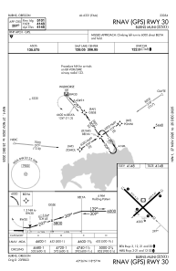
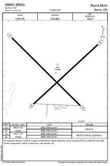


KBNO - Burns Muni
Located in Burns, United States
ICAO - BNO, IATA - BNO
Data provided by AirmateGeneral information
Coordinates: N43°35'31" W118°57'20"
Elevation is 4148 feet MSL.
Magnetic variation is 18° East View others Airports in Oregon
Operational data
Special qualification required
Current time UTC:
Current local time:
Weather
METAR: KBNO 030053Z AUTO 32014KT 10SM FEW070 OVC085 11/02 A2995 RMK AO2 PK WND 30027/2359 SLP145 T01060017
TAF: KBNO 022320Z 0300/0324 33014G22KT P6SM VCSH BKN050 FM030200 32006KT P6SM SCT060 FM030900 VRB04KT P6SM FEW002 FM031800 12010G16KT P6SM BKN200
Communications frequencies: [VIEW]
Runways:
| RWY identifier | QFU | Length (ft) | Width (ft) | Surface | LDA (ft) |
| 03 | 48° | 4600 | 60 | CONC | |
| 21 | 228° | 4600 | 60 | CONC | |
| 12 | 135° | 5101 | 75 | CONC | |
| 30 | 315° | 5101 | 75 | CONC |
Airport contact information
Address: Burns United States