


KBKT - Allen C Perkinson Blackstone Aaf
Located in Blackstone, United States
ICAO - BKT, IATA - BKT
Data provided by AirmateGeneral information
Coordinates: N37°4'29" W77°57'24"
Elevation is 437 feet MSL.
Magnetic variation is -09° East View others Airports in Virginia
Operational data
Special qualification required
Current time UTC:
Current local time:
Weather
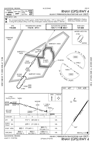
METAR: KBKT 271755Z AUTO 12003KT 10SM SCT050 OVC070 15/11 A3043 RMK AO1 T01520111 10152 20098
Communications frequencies: [VIEW]
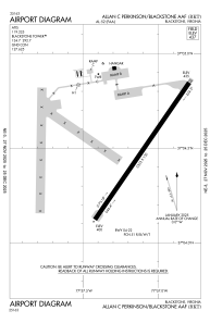
Runways:
| RWY identifier | QFU | Length (ft) | Width (ft) | Surface | LDA (ft) |
| 04 | 35° | 5333 | 150 | CONC | |
| 22 | 215° | 5333 | 150 | CONC |
Airport contact information
Address: Blackstone United States