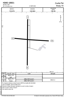


KBBD - Curtis Fld
Located in Brady, United States
ICAO - BBD, IATA - BBD
Data provided by AirmateGeneral information
Coordinates: N31°10'45" W99°19'26"
Elevation is 1827 feet MSL.
Magnetic variation is 07° East View others Airports in Texas
Operational data
Special qualification required
Current time UTC:
Current local time:
Weather
METAR: KBBD 300415Z AUTO 13006KT 10SM FEW035 BKN044 OVC055 22/15 A2990 RMK AO2
TAF: KBBD 292324Z 3000/3024 13007KT P6SM FEW100 FM300300 13012KT P6SM FEW250 FM300900 18009KT P6SM BKN016 FM301400 18011KT P6SM BKN230 FM302200 16012KT P6SM FEW250
Communications frequencies: [VIEW]
Runways:
| RWY identifier | QFU | Length (ft) | Width (ft) | Surface | LDA (ft) |
| 08 | 93° | 3520 | 110 | GRASS | |
| 26 | 273° | 3520 | 110 | GRASS | |
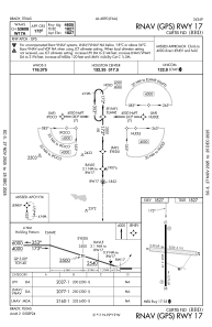
| 17 | 180° | 4605 | 75 | ASPH | |
| 35 | 0° | 4605 | 75 | ASPH |
Airport contact information
Address: Brady United States
