


KBAM - Battle Mountain
Located in Battle Mountain, United States
ICAO - BAM, IATA - BAM
Data provided by AirmateGeneral information
Coordinates: N40°35'57" W116°52'28"
Elevation is 4536 feet MSL.
Magnetic variation is 13° East View others Airports in Nevada
Operational data
Special qualification required
Current time UTC:
Current local time:
Weather
METAR: KBAM 260655Z AUTO 20004KT 10SM SCT033 BKN038 OVC047 08/07 A2988 RMK AO1
TAF: KBAM 260520Z 2606/2706 29009KT 6SM -SHRA SCT025 OVC040 FM261200 29007KT 6SM -SHRA OVC025 FM262000 32011KT 6SM -SHRA VCTS SCT025 BKN050CB FM270200 32008KT P6SM VCSH BKN050
Communications frequencies: [VIEW]
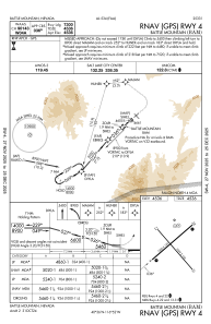
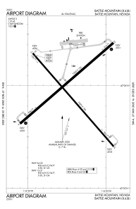
Runways:
| RWY identifier | QFU | Length (ft) | Width (ft) | Surface | LDA (ft) |
| 04 | 49° | 7300 | 150 | ASPH | |
| 22 | 229° | 7300 | 150 | ASPH | |
| 13 | 139° | 7299 | 100 | ASPH | |
| 31 | 319° | 7299 | 100 | ASPH |
Airport contact information
Address: Battle Mountain United States