


KAPC - Napa County
Located in Napa, United States
ICAO - APC, IATA - APC
Data provided by AirmateGeneral information
Coordinates: N38°12'47" W122°16'50"
Elevation is 35 feet MSL.
Magnetic variation is 15° East View others Airports in California
Operational data
Special qualification required
Current time UTC:
Current local time:
Weather
METAR: KAPC 300554Z AUTO 27004KT 10SM CLR 10/07 A3003 RMK AO2 SLP161 T01000067 10194 20100 51012
TAF: KAPC 300520Z 3006/0106 28009KT P6SM SKC FM301000 30005KT P6SM SKC FM301800 25012KT P6SM SKC FM010400 27008KT P6SM SKC
Communications frequencies: [VIEW]
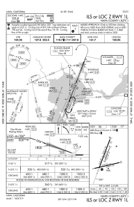
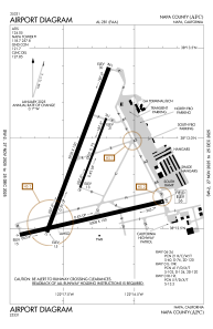
Runways:
| RWY identifier | QFU | Length (ft) | Width (ft) | Surface | LDA (ft) |
| 01L | 21° | 5930 | 150 | ASPH | |
| 19R | 201° | 5930 | 150 | ASPH | |
| 01R | 21° | 2510 | 75 | ASPH | |
| 19L | 201° | 2510 | 75 | ASPH | |
| 06 | 77° | 5008 | 150 | CONC | |
| 24 | 257° | 5008 | 150 | CONC |
Airport contact information
Address: Napa United States
