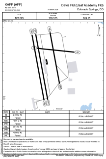


KAFF - Usaf Academy Airfield
Located in Colorado Springs, United States
ICAO - AFF, IATA - AFF
Data provided by AirmateGeneral information
Coordinates: N38°58'24" W104°49'12"
Elevation is 6576 feet MSL.
Magnetic variation is 11° East View others Airports in Colorado
Operational data
Special qualification required
Current time UTC:
Current local time:
Weather
METAR: KAFF 262104Z 06006KT 10SM VCSH OVC080 15/M00 A2963 RMK AO2A SLP981
TAF: TAF COR KAFF 262006Z 2619/2801 36012KT 9999 VCSH BKN080 610809 520204 QNH2960INS WND 270V090 BECMG 2620/2621 VRB09KT 9999 -SHRA VCTS BKN070CB QNH2960INS TEMPO 2621/2702 VRB20G30KT 8000 -TSRA BECMG 2701/2702 35012KT 9999 VCSH SCT030 BKN080 QNH2966INS BECMG 2707/2708 02012KT 4800 -SHRA VCTS BKN010 OVC015CB QNH2970INS BECMG 2711/2712 01012KT 2400 RASN VCTS BKN007 OVC012CB QNH2970INS BECMG 2718/2719 36015G28KT 4800 -SHRASN VCTS SCT007 BKN012CB OVC020 QNH2968INS TX19/2620Z TN02/2714Z LAST NO AMDS AFT 2620 NEXT 2911
Communications frequencies: [VIEW]
Runways:
| RWY identifier | QFU | Length (ft) | Width (ft) | Surface | LDA (ft) |
| 08 | 96° | 2485 | 75 | ASPH | |
| 26 | 276° | 2485 | 75 | ASPH | |
| 16C | 170° | 4480 | 75 | ASPH | |
| 34C | 350° | 4480 | 75 | ASPH | |
| 16R | 169° | 4500 | 40 | ASPH | |
| 34L | 349° | 4500 | 40 | ASPH | |
| 16L | 170° | 3534 | 75 | ASPH | |
| 34R | 350° | 3534 | 75 | ASPH |
Airport contact information
Address: Colorado Springs United States