


KABI - Abilene Rgnl
Located in Abilene, United States
ICAO - ABI, IATA - ABI
Data provided by AirmateGeneral information
Coordinates: N32°24'41" W99°40'55"
Elevation is 1790 feet MSL.
Magnetic variation is 05° East View others Airports in Texas
Operational data
Special qualification required
Current time UTC:
Current local time:
Weather
METAR: KABI 300652Z A2988 RMK AO2 SLPNO $
TAF: KABI 300527Z 3006/0106 15015KT P6SM SKC FM301400 19018G25KT P6SM SKC FM010000 15016G24KT P6SM BKN250 AMD NOT SKED
Communications frequencies: [VIEW]
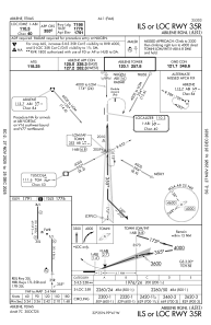
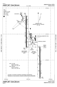
Runways:
| RWY identifier | QFU | Length (ft) | Width (ft) | Surface | LDA (ft) |
| 17L | 180° | 7198 | 150 | ASPH | 7198 |
| 35R | 360° | 7198 | 150 | ASPH | 7198 |
| 17R | 180° | 7208 | 150 | ASPH | 7202 |
| 35L | 360° | 7208 | 150 | ASPH | 7202 |
Airport contact information
Address: Abilene United States
