


K26 - Carrollton Meml
Located in Carrollton, United States
ICAO - K26, IATA -
Data provided by AirmateGeneral information
Coordinates: N39°18'44" W93°30'24"
Elevation is 670 feet MSL.
Magnetic variation is 04° East View others Airports in Missouri
Operational data
Special qualification required
Current time UTC:
Current local time:
Weather at : KMHL - Marshall Meml Muni ( 36 km )
METAR: KMHL 280055Z AUTO 14009KT 10SM VCTS CLR 21/18 A2983 RMK AO2 LTG DSNT W THRU E
Communications frequencies: [VIEW]
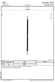
Runways:
| RWY identifier | QFU | Length (ft) | Width (ft) | Surface | LDA (ft) |
| 18 | 181° | 2600 | 50 | ASPH | |
| 36 | 1° | 2600 | 50 | ASPH |
Airport contact information
Address: Carrollton United States