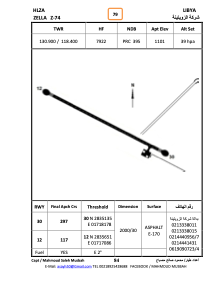


HLZA - Zella - Z74
Located in , Libyan Arab Jamahiriya
ICAO - HLZA, IATA -
Data provided by AirmateGeneral information
Coordinates: N28°35'22" E17°17'41"
Elevation is 1101 feet MSL.
Magnetic variation is 3° East View others Airports in Al Jufrah District
Operational data
Special qualification required
Current time UTC:
Current local time:
Weather at : - ( 0 km )
METAR: YPXM 262322Z AUTO 12005KT 9999 // SCT010 BKN060 BKN071 24/24 Q1010
Communications frequencies: [VIEW]
Runways:
| RWY identifier | QFU | Length (ft) | Width (ft) | Surface | LDA (ft) |
| 05 | 47° | 4917 | 81 | SAND | |
| 23 | 227° | 4917 | 81 | SAND | |
| 12 | 119° | 6646 | 94 | ASPH | |
| 30 | 299° | 6646 | 94 | ASPH |
Airport contact information
Address: Libyan Arab Jamahiriya