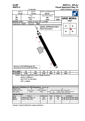
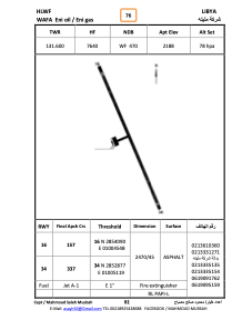


HLWF - Wafa
Located in , Libyan Arab Jamahiriya
ICAO - , IATA -
Data provided by AirmateGeneral information
Coordinates: N28°53'29" E10°4'50"
Elevation is 2188 feet MSL.
Magnetic variation is 2° East View others Airports in Wadi Al Shatii District
Operational data
Special qualification required
Current time UTC:
Current local time:
Weather at : - ( 0 km )
METAR: KORB 030333Z AUTO 14005KT 10SM -DZ OVC017 06/05 A2978 RMK AO2
Communications frequencies: [VIEW]
Runways:
| RWY identifier | QFU | Length (ft) | Width (ft) | Surface | LDA (ft) |
| 16 | 158° | 8086 | 92 | ASPH | |
| 34 | 338° | 8086 | 92 | ASPH |
Airport contact information
Address: Libyan Arab Jamahiriya