


HLWD - Beni Walid
Located in Bani Walid, Libyan Arab Jamahiriya
ICAO - , IATA - QBL
Data provided by AirmateGeneral information
Coordinates: N31°44'23" E13°57'14"
Elevation is 1000 feet MSL.
Magnetic variation is 3° East View others Airports in Misurata District
Operational data
Special qualification required
Current time UTC:
Current local time:
Weather at : - ( 0 km )
METAR: CYAT 231237Z AUTO 31013G19KT 9SM SCT019 SCT050 OVC100 01/M00 A2970 RMK SLP059
Communications frequencies: [VIEW]
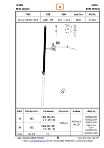
Runways:
| RWY identifier | QFU | Length (ft) | Width (ft) | Surface | LDA (ft) |
| 18 | 0° | 5906 | 148 | ASPH | |
| 36 | 0° | 5906 | 148 | ASPH |
Airport contact information
Address: Bani Walid Libyan Arab Jamahiriya