


HLWA - Waha - Wh59A
Located in , Libyan Arab Jamahiriya
ICAO - HLWA, IATA -
Data provided by AirmateGeneral information
Coordinates: N28°19'19" E19°55'48"
Elevation is 480 feet MSL.
Magnetic variation is 4° East View others Airports in Al Wahat District
Operational data
Special qualification required
Current time UTC:
Current local time:
Weather at : - ( 0 km )
METAR: PANA 260427Z AUTO 00000KT 10SM -RA SCT017 OVC050 03/02 A2977 RMK AO2 P0000 TSNO
Communications frequencies: [VIEW]
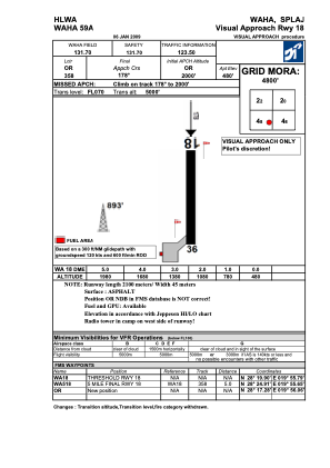
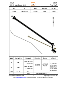
Runways:
| RWY identifier | QFU | Length (ft) | Width (ft) | Surface | LDA (ft) |
| 18 | 179° | 6873 | 99 | ASPH | |
| 36 | 359° | 6873 | 99 | ASPH |
Airport contact information
Address: Libyan Arab Jamahiriya