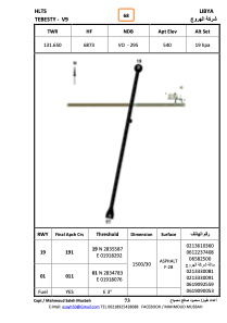


HLTS - Tebesty - V9
Located in Zaltan, Libyan Arab Jamahiriya
ICAO - , IATA -
Data provided by AirmateGeneral information
Coordinates: N28°35'22" E19°18'15"
Elevation is 540 feet MSL.
Magnetic variation is 4° East View others Airports in Al Wahat District
Operational data
Special qualification required
Current time UTC:
Current local time:
Weather at : - ( 0 km )
METAR: CYYG 262252Z 07005KT 15SM SKC 02/M10 A3043 RMK SLP308
Communications frequencies: [VIEW]
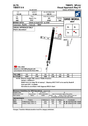
Runways:
| RWY identifier | QFU | Length (ft) | Width (ft) | Surface | LDA (ft) |
| 09 | 92° | 2024 | 77 | SAND | |
| 27 | 272° | 2024 | 77 | SAND | |
| 01 | 13° | 5112 | 86 | ASPH | |
| 19 | 193° | 5112 | 86 | ASPH |
Airport contact information
Address: Zaltan Libyan Arab Jamahiriya