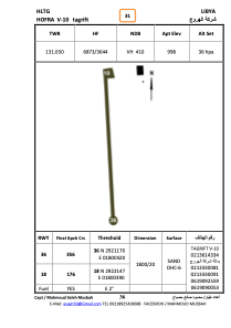


HLTG - Tagrift - V10
Located in , Libyan Arab Jamahiriya
ICAO - , IATA -
Data provided by AirmateGeneral information
Coordinates: N29°21'41" E18°0'26"
Elevation is 998 feet MSL.
Magnetic variation is 3° East View others Airports in Surt District
Operational data
Special qualification required
Current time UTC:
Current local time:
Weather at : - ( 0 km )
METAR: CYPL 260937Z AUTO 18014G25KT 9SM FEW060 BKN076 OVC100 06/M04 A2992 RMK SLP148
Communications frequencies: [VIEW]
Runways:
| RWY identifier | QFU | Length (ft) | Width (ft) | Surface | LDA (ft) |
| 18 | 178° | 5368 | 103 | SAND | |
| 36 | 358° | 5368 | 103 | SAND |
Airport contact information
Address: Libyan Arab Jamahiriya