


HLSB - Sabah - S74
Located in , Libyan Arab Jamahiriya
ICAO - , IATA -
Data provided by AirmateGeneral information
Coordinates: N28°13'21" E18°6'34"
Elevation is 949 feet MSL.
Magnetic variation is 3° East View others Airports in Al Jufrah District
Operational data
Special qualification required
Current time UTC:
Current local time:
Weather at : - ( 0 km )
METAR: NZCM 050306Z AUTO 14026G35KT 9999 -SN FEW048 OVC070 M11/M14 A2813 RMK AO2 PK WND 15035/0305 SNB0306 SLP530 T11051143 $
Communications frequencies: [VIEW]
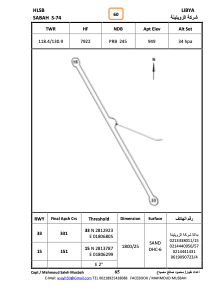
Runways:
| RWY identifier | QFU | Length (ft) | Width (ft) | Surface | LDA (ft) |
| 15 | 153° | 5563 | 111 | SAND | |
| 33 | 333° | 5563 | 111 | SAND |
Airport contact information
Address: Libyan Arab Jamahiriya