


HLOKN - Okba Ibn Nafa
Located in , Libyan Arab Jamahiriya
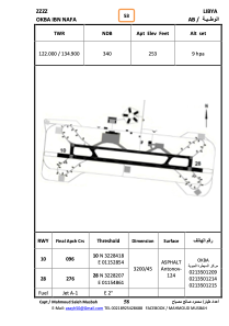
ICAO - , IATA -
Data provided by AirmateGeneral information
Coordinates: N32°28'19" E11°53'45"
Elevation is 253 feet MSL.
Operational data
Special qualification required
Current time UTC:
Current local time:
Weather at : - ( 0 km )
METAR: KW96 100315Z AUTO 08006KT 10SM SCT043 BKN050 19/17 A2962 RMK AO1 T01860174
Communications frequencies: [VIEW]
Runways:
| RWY identifier | QFU | Length (ft) | Width (ft) | Surface | LDA (ft) |
| 27 | 277° | 10481 | 143 | ASPH | |
| 09 | 97° | 10481 | 143 | ASPH |
Airport contact information
Address: Libyan Arab Jamahiriya