


HLNR - Nafoora - M4
Located in Jakharrah, Libyan Arab Jamahiriya
ICAO - HLNR, IATA - NFR
Data provided by AirmateGeneral information
Coordinates: N29°13'6" E21°35'24"
Elevation is 128 feet MSL.
Magnetic variation is 4° East View others Airports in Al Wahat District
Operational data
Special qualification required
Current time UTC:
Current local time:
Weather at : - ( 0 km )
METAR: PAHX 032102Z AUTO 03013KT 10SM OVC047 06/M01 A2962 RMK AO2 SLP030 60000 T00611011 58030
Communications frequencies: [VIEW]
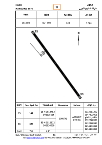
Runways:
| RWY identifier | QFU | Length (ft) | Width (ft) | Surface | LDA (ft) |
| 15 | 147° | 9835 | 136 | ASPH | |
| 33 | 327° | 9835 | 136 | ASPH |
Airport contact information
Address: Jakharrah Libyan Arab Jamahiriya