


HLNC - N29C
Located in , Libyan Arab Jamahiriya
ICAO - , IATA -
Data provided by AirmateGeneral information
Coordinates: N29°43'54" E17°56'48"
Elevation is 903 feet MSL.
Magnetic variation is 3° East View others Airports in Surt District
Operational data
Special qualification required
Current time UTC:
Current local time:
Weather at : - ( 0 km )
METAR: LWSK 262020Z 09003KT 060V130 9999 FEW082 09/07 Q1015 NOSIG
Communications frequencies: [VIEW]
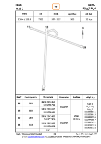
Runways:
| RWY identifier | QFU | Length (ft) | Width (ft) | Surface | LDA (ft) |
| 18 | 185° | 6148 | 65 | SAND | |
| 36 | 5° | 6148 | 65 | SAND | |
| 12 | 115° | 5977 | 82 | SAND | |
| 30 | 295° | 5977 | 82 | SAND |
Airport contact information
Address: Libyan Arab Jamahiriya