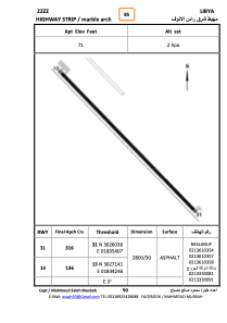


HLMAR - Marble Arch Highway Strip
Located in , Libyan Arab Jamahiriya
ICAO - , IATA -
Data provided by AirmateGeneral information
Coordinates: N30°26'36" E18°34'50"
Elevation is 71 feet MSL.
Operational data
Special qualification required
Current time UTC:
Current local time:
Weather at : - ( 0 km )
METAR: ZMUB 140400Z VRB02MPS CAVOK 11/M15 Q1031 NOSIG RMK QFE664.6 16
Communications frequencies: [VIEW]
Runways:
| RWY identifier | QFU | Length (ft) | Width (ft) | Surface | LDA (ft) |
| 31 | 318° | 9140 | 89 | ASPH | |
| 13 | 138° | 9140 | 89 | ASPH |
Airport contact information
Address: Libyan Arab Jamahiriya