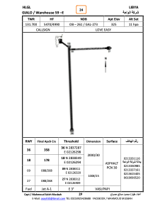


HLGL - Gialo - Wh59E
Located in , Libyan Arab Jamahiriya
ICAO - HLGL, IATA -
Data provided by AirmateGeneral information
Coordinates: N28°38'19" E21°26'17"
Elevation is 325 feet MSL.
Magnetic variation is 4° East View others Airports in Al Wahat District
Operational data
Special qualification required
Current time UTC:
Current local time:
Communications frequencies: [VIEW]
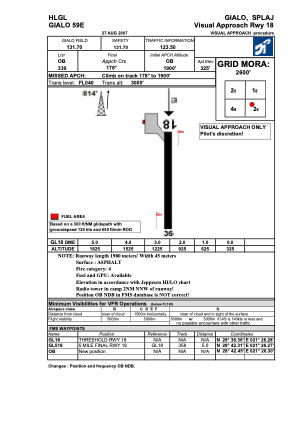
Runways:
| RWY identifier | QFU | Length (ft) | Width (ft) | Surface | LDA (ft) |
| 09 | 90° | 3270 | 79 | ASPH | |
| 27 | 270° | 3270 | 79 | ASPH | |
| 18 | 180° | 6549 | 95 | ASPH | |
| 36 | 360° | 6549 | 95 | ASPH |
Airport contact information
Address: Libyan Arab Jamahiriya