


HLATS - Atshan field
Located in Tamantit, Libyan Arab Jamahiriya
ICAO - , IATA -
Data provided by AirmateGeneral information
Coordinates: N27°45'11" E11°2'37"
Elevation is 1648 feet MSL.
Magnetic variation is 0° East View others Airports in Wadi Al Shatii District
Operational data
Special qualification required
Current time UTC:
Current local time:
Weather at : - ( 0 km )
METAR: KUNV 261653Z 21007G17KT 10SM CLR 14/02 A3039
Communications frequencies: [VIEW]
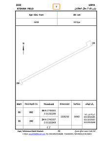
Runways:
| RWY identifier | QFU | Length (ft) | Width (ft) | Surface | LDA (ft) |
| 06 | 62° | 4116 | 171 | SAND | |
| 24 | 242° | 4116 | 171 | SAND |
Airport contact information
Address: Tamantit Libyan Arab Jamahiriya