
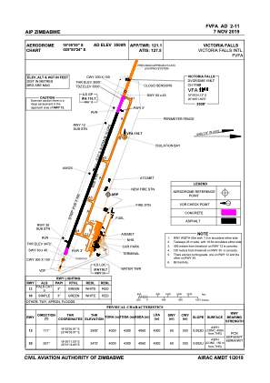


FVFA - Victoria Falls
Located in Victoria Falls, Zimbabwe
ICAO - FVFA, IATA - VFA
Data provided by AirmateGeneral information
Coordinates: S18°5'39" E25°50'24"
Elevation is 3500 feet MSL.
View others Airports in Matabeleland North
Operational data
Special qualification required
Current time UTC:
Current local time:
Weather
METAR: FVFA 260700Z 08012KT CAVOK 26/11 Q1020 NOSIG
Communications frequencies: [VIEW]
Runways:
| RWY identifier | QFU | Length (ft) | Width (ft) | Surface | LDA (ft) |
| 12 | 111° | 13123 | 148 | ASP | |
| 30 | 291° | 13123 | 148 | ASP |
Airport contact information
Address: Victoria Falls Zimbabwe