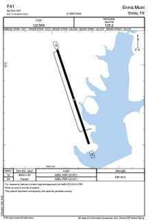


F41 - Ennis Muni
Located in Ennis, United States
ICAO - F41, IATA -
Data provided by AirmateGeneral information
Coordinates: N32°19'47" W96°39'50"
Elevation is 500 feet MSL.
Magnetic variation is 03° East View others Airports in Texas
Operational data
Special qualification required
Current time UTC:
Current local time:
Weather at : KJWY - Mid-Way Rgnl ( 27 km )
METAR: KJWY 300055Z AUTO 00000KT 10SM SCT110 23/19 A2990 RMK AO2 T02250185
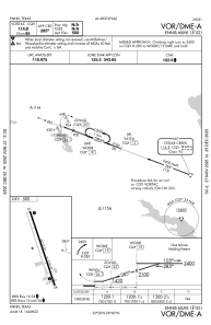
Communications frequencies: [VIEW]
Runways:
| RWY identifier | QFU | Length (ft) | Width (ft) | Surface | LDA (ft) |
| 16 | 161° | 3999 | 50 | ASPH | |
| 34 | 341° | 3999 | 50 | ASPH |
Airport contact information
Address: Ennis United States