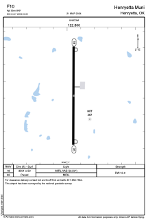


F10 - Henryetta Muni
Located in Henryetta, United States
ICAO - F10, IATA -
Data provided by AirmateGeneral information
Coordinates: N35°24'25" W96°0'57"
Elevation is 849 feet MSL.
Magnetic variation is 04° East View others Airports in Oklahoma
Operational data
Special qualification required
Current time UTC:
Current local time:
Weather at : KOKM - Okmulgee Rgnl/Paul And Betty Abbott Fld ( 30 km )
METAR: KOKM 262135Z AUTO 19015G30KT 10SM SCT024 26/20 A2959 RMK AO2 LTG DSNT N T02610195
Communications frequencies: [VIEW]
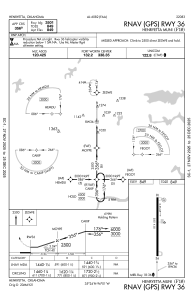
Runways:
| RWY identifier | QFU | Length (ft) | Width (ft) | Surface | LDA (ft) |
| 18 | 180° | 3501 | 50 | ASPH | |
| 36 | 360° | 3501 | 50 | ASPH |
Airport contact information
Address: Henryetta United States