


EYPH - Paluknys/Av
Located in Paluknys, Lithuania
ICAO - , IATA -
Data provided by AirmateGeneral information
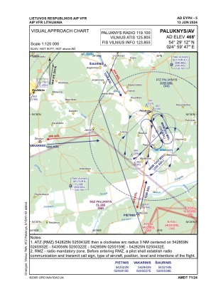
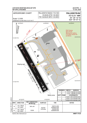
Coordinates: N54°29'12" E24°59'47"
Elevation is 468 feet MSL.
Magnetic variation is 8° East View others Airports in Vilnius County
Operational data
Special qualification required
Current time UTC:
Current local time:
Weather at : EYVI - Vilnius/International ( 25 km )
METAR: EYVI 061620Z 06006KT 9999 BKN030CB 11/08 Q1005 NOSIG
TAF: TAF EYVI 061100Z 0612/0712 VRB05KT 9000 BKN020 TEMPO 0612/0614 5000 TSRA SCT005 BKN015CB TEMPO 0614/0620 VRB15KT 1500 TSRA BKN005 BKN015CB BECMG 0620/0621 OVC010 TEMPO 0621/0624 5000 TSRA BKN005 BKN015CB BECMG 0700/0701 36015KT TEMPO 0701/0706 5000 SHRA BKN005 BKN015CB BECMG 0706/0708 SCT025
Communications frequencies: [VIEW]
Runways:
| RWY identifier | QFU | Length (ft) | Width (ft) | Surface | LDA (ft) |
| 14 | 0° | 620 | 66 | UNK | |
| 32 | 0° | 620 | 66 | UNK |
Airport contact information
Address: Paluknys Lithuania