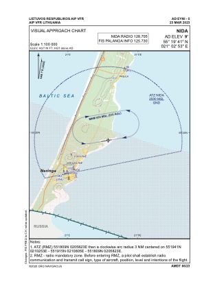
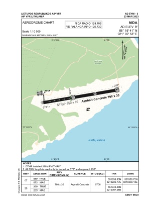


EYNI - Nida
Located in Nida, Lithuania
ICAO - , IATA -
Data provided by AirmateGeneral information
Coordinates: N55°19'41" E21°2'53"
Elevation is 9 feet MSL.
Magnetic variation is 7° East View others Airports in Klaipeda County
Operational data
Special qualification required
Current time UTC:
Current local time:
Weather at : UMKK - Kaliningrad/Khrabrovo ( 56 km )
TAF: TAF UMKK 261955Z 2621/2721 15003G08MPS 6000 NSC BECMG 2704/2707 19004G11MPS SCT020CB BECMG 2715/2717 VRB01MPS BECMG 2718/2720 12003G08MPS
Communications frequencies: [VIEW]
Runways:
| RWY identifier | QFU | Length (ft) | Width (ft) | Surface | LDA (ft) |
| 07 | 80° | 2592 | 98 | CONC+ASPH | |
| 25 | 260° | 2592 | 98 | CONC+ASPH |
Airport contact information
Address: Nida Lithuania