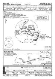
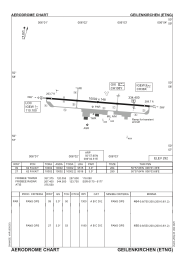


ETNG - Geilenkirchen
Located in Geilenkirchen, Germany
ICAO - ETNG, IATA - GKE
Data provided by AirmateGeneral information
Coordinates: N50°57'39" E6°2'30"
Elevation is 292 feet MSL.
Magnetic variation is 2.78° East View others Airports in North Rhine-Westphalia
Operational data
Special qualification required
Current time UTC:
Current local time:
Weather
TAF: TAF ETNG 030200Z 0303/0318 24013G23KT 7000 -RA BKN010 TEMPO 0303/0307 3500 RADZ BKN005 BECMG 0307/0309 BKN015 TEMPO 0307/0312 24015G27KT BECMG 0310/0312 BKN025 BECMG 0312/0314 9999 NSW BECMG 0315/0317 24007KT
Communications frequencies: [VIEW]
Runways:
| RWY identifier | QFU | Length (ft) | Width (ft) | Surface | LDA (ft) |
| 09 | 91° | 10002 | 148 | ASPH | 9515 |
| 27 | 271° | 10002 | 148 | ASPH | 9516 |
Airport contact information
Address: Geilenkirchen Germany