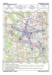


ETHF - Fritzlar
Located in Fritzlar, Germany
ICAO - ETHF, IATA - FRZ
Data provided by AirmateGeneral information
Coordinates: N51°6'52" E9°17'9"
Elevation is 565 feet MSL.
Magnetic variation is 3.52° East View others Airports in Hesse
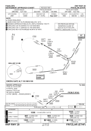
Operational data
Special qualification required
Current time UTC:
Current local time:
Weather
METAR: ETHF 261520Z 20009KT 9999 FEW049 BKN070 13/03 Q1005 BLU
TAF: TAF ETHF 260720Z 2608/2617 19010G20KT 9999 NSW SCT060 BKN120
Communications frequencies: [VIEW]
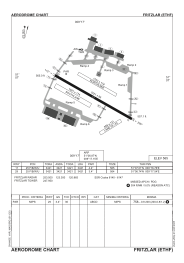
Runways:
| RWY identifier | QFU | Length (ft) | Width (ft) | Surface | LDA (ft) |
| 12 | 119° | 3421 | 98 | CONC+ASPH | 3421 |
| 30 | 299° | 3421 | 98 | CONC+ASPH | 3421 |
Airport contact information
Address: Fritzlar Germany