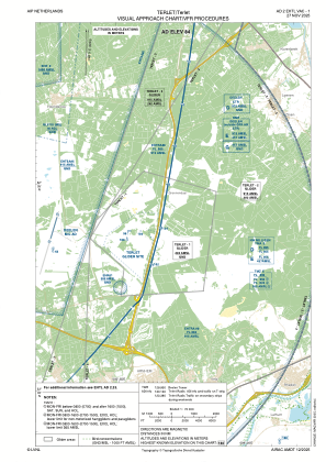
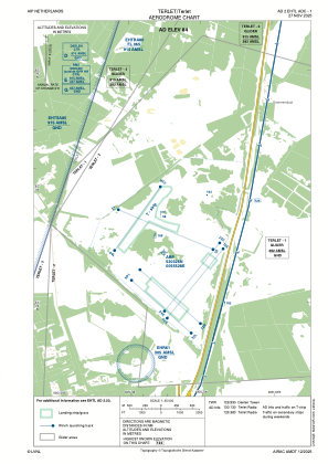


EHTL - Terlet
Located in Arnhem, Netherlands
ICAO - EHTL, IATA -
Data provided by AirmateGeneral information
Coordinates: N52°3'26" E5°55'28"
Elevation is 276 feet MSL.
Magnetic variation is 1.8895° East View others Airports in Gelderland
Operational data
Special qualification required
Current time UTC:
Current local time:
Weather at : EHDL - Deelen ( 4 km )
METAR: EHDL 262025Z AUTO 09001KT 9999 OVC041 09/04 Q1006 BLU
Communications frequencies: [VIEW]
Runways:
| RWY identifier | QFU | Length (ft) | Width (ft) | Surface | LDA (ft) |
| 04L | 0° | 4000 | 500 | grass | |
| 22R | 0° | 4000 | 500 | grass | |
| 04C | 0° | 4100 | 700 | grass | |
| 22C | 0° | 4100 | 700 | grass | |
| 04R | 0° | 4100 | 700 | grass | |
| 22L | 0° | 4100 | 700 | grass | |
| 12 | 0° | 3600 | 560 | grass | |
| 30 | 0° | 3600 | 560 | grass | |
| 14L | 0° | 4500 | 910 | grass | |
| 32R | 0° | 4500 | 910 | grass | |
| 14R | 0° | 4500 | 910 | grass | |
| 32L | 0° | 4500 | 910 | grass |
Airport contact information
Address: Arnhem Netherlands