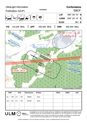


EBCF - Cerfontaine
Located in Cerfontaine, Belgium
ICAO - EBCF, IATA -
Data provided by AirmateGeneral information
Coordinates: N50°9'10" E4°23'14"
Elevation is 951 feet MSL.
Magnetic variation is 1° East View others Airports in Namur
Operational data
Special qualification required
Current time UTC:
Current local time:
Weather at : EBFS - Florennes ( 21 km )
METAR: EBFS 032255Z AUTO 18006KT 9999 FEW110/// BKN220/// 09/06 Q1015 BLU
TAF: TAF EBFS 031541Z 0319/0407 17010KT 9999 FEW030 SCT150 BECMG 0401/0403 SCT005
Communications frequencies: [VIEW]
Runways:
| RWY identifier | QFU | Length (ft) | Width (ft) | Surface | LDA (ft) |
| 11L | 0° | 2618 | 66 | GRASS | |
| 29R | 0° | 2618 | 66 | GRASS | |
| 11R | 0° | 2215 | 98 | GRASS | |
| 29L | 0° | 2215 | 98 | GRASS |
Airport contact information
Address: Cerfontaine Belgium