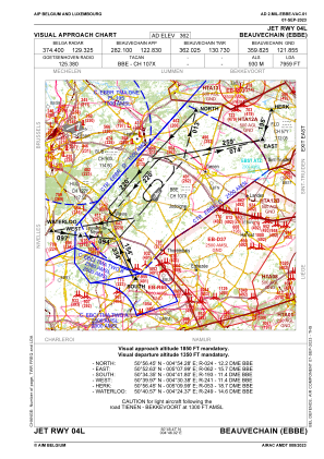
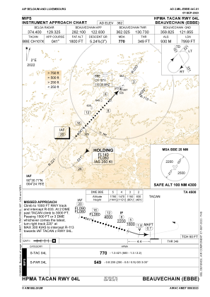
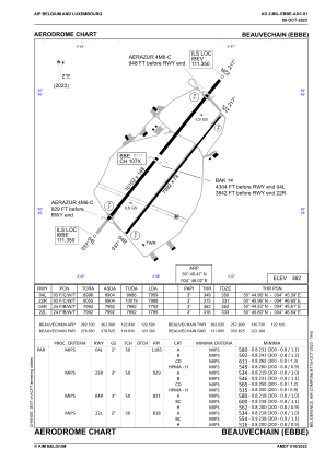


EBBE - Beauvechain
Located in Beauvechain, Belgium
ICAO - EBBE, IATA -
Data provided by AirmateGeneral information
Coordinates: N50°45'28" E4°46'1"
Elevation is 362 feet MSL.
Magnetic variation is 2° East View others Airports in Walloon Brabant
Operational data
Special qualification required
Current time UTC:
Current local time:
Weather
METAR: EBBE 261225Z 29006KT 9999 FEW010 BKN040 10/07 Q1004 BLU BLU TEMPO WHT
TAF: TAF EBBE 261141Z 2613/2622 23005KT 9999 FEW020 BKN030 TEMPO 2613/2618 24008G18KT 7000 -SHRA SCT025TCU BKN030 PROB40 TEMPO 2613/2616 25010G20KT 4000 SHRA SCT023TCU BKN028 BECMG 2614/2616 VRB03KT
Communications frequencies: [VIEW]
Runways:
| RWY identifier | QFU | Length (ft) | Width (ft) | Surface | LDA (ft) |
| 04L | 39° | 10085 | 148 | CONC+ASPH | 7989 |
| 22R | 219° | 10085 | 148 | CONC+ASPH | 7976 |
| 04R | 39° | 8038 | 74 | CONC+ASPH | 7838 |
| 22L | 219° | 8038 | 74 | CONC+ASPH | 7835 |
Airport contact information
Address: Beauvechain Belgium
Other aviation service providers
Aviation club (not for profit)

Belgian Air Cadets (Military) Planeurs
Belgian Air Cadets (Military) Planeurs
ccair-bac-srt@mil.be+3224425650