


D49 - Columbus Muni
Located in Columbus, United States
ICAO - D49, IATA -
Data provided by AirmateGeneral information
Coordinates: N48°53'58" W102°47'32"
Elevation is 1931 feet MSL.
Magnetic variation is 12° East View others Airports in North Dakota
Operational data
Special qualification required
Current time UTC:
Current local time:
Weather at : CYEN - Estevan Regional ( 37 km )
METAR: CYEN 270700Z AUTO 03009KT 9SM CLR 05/M01 A2983 RMK SLP110
TAF: TAF AMD CYEN 262318Z 2623/2624 06015G25KT P6SM BKN100 RMK FCST BASED ON AUTO OBS. NXT FCST BY 271200Z
Communications frequencies: [VIEW]
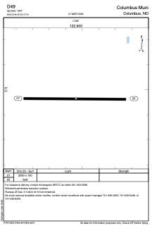
Runways:
| RWY identifier | QFU | Length (ft) | Width (ft) | Surface | LDA (ft) |
| 07 | 90° | 2560 | 100 | GRASS | |
| 25 | 270° | 2560 | 100 | GRASS |
Airport contact information
Address: Columbus United States