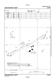


CYXP - Pangnirtung
Located in Pangnirtung, Canada
ICAO - CYXP, IATA - YXP
Data provided by AirmateGeneral information
Coordinates: N66°8'42" W65°42'49"
Elevation is 79 feet MSL.
Magnetic variation is -28.5953° East View others Airports in Nunavut
Operational data
Special qualification required
Current time UTC:
Current local time:
Weather
METAR: CYXP 261800Z 23010KT 15SM FEW016 M05/M13 A3008 RMK SF1 SF TR WIND EST SLP192
TAF: TAF CYXP 261840Z 2619/2622 23010KT P6SM FEW015 SCT030 RMK NXT FCST BY 271600Z
Communications frequencies: [VIEW]
Runways:
| RWY identifier | QFU | Length (ft) | Width (ft) | Surface | LDA (ft) |
| 06 | 62° | 2920 | 98 | GRAVE | 2920 |
| 24 | 242° | 2920 | 98 | GRAVE | 2920 |
Airport contact information
Address: Pangnirtung Canada