


CYAV - St. Andrews
Located in Winnipeg, Canada
ICAO - CYAV, IATA -
Data provided by AirmateGeneral information
Coordinates: N50°3'23" W97°1'57"
Elevation is 759 feet MSL.
Magnetic variation is 4° East View others Airports in Manitoba
Operational data
Special qualification required
Current time UTC:
Current local time:
Weather at : CYWG - James Armstrong Richardson Intl ( 22 km )
METAR: CYWG 261247Z 18020G28KT 15SM BKN066 13/01 A2970 RMK AC7 SLP063 DENSITY ALT 1000FT
TAF: TAF CYWG 261140Z 2612/2712 18020G30KT P6SM OVC050 TEMPO 2612/2615 P6SM -RA FEW015 OVC030 FM261500 20012KT P6SM -RA SCT015 OVC030 TEMPO 2615/2624 5SM -SHRA BR OVC015 FM270000 14012KT P6SM -RA SCT008 OVC015 TEMPO 2700/2706 4SM -SHRA BR OVC008 BECMG 2700/2702 08008KT FM270600 03010KT 4SM -SHRA BR OVC006 RMK NXT FCST BY 261800Z
Communications frequencies: [VIEW]
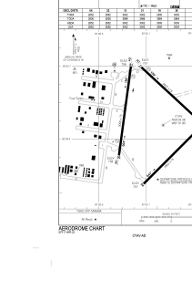
Runways:
| RWY identifier | QFU | Length (ft) | Width (ft) | Surface | LDA (ft) |
| 13 | 133° | 3002 | 75 | ASPH | 3002 |
| 31 | 313° | 3002 | 75 | ASPH | 3002 |
| 04 | 45° | 2852 | 75 | ASPH | 2852 |
| 22 | 225° | 2852 | 75 | ASPH | 2852 |
| 18 | 188° | 3000 | 75 | ASPH | 3000 |
| 36 | 8° | 3000 | 75 | ASPH | 3000 |
Airport contact information
Address: Winnipeg Canada

