


CEH3 - Ponoka (Labrie Field)
Located in , Canada
ICAO - CEH3, IATA -
Data provided by AirmateGeneral information
Coordinates: N52°39'7" W113°36'16"
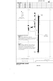
Elevation is 2669 feet MSL.
Magnetic variation is 14.8783° East View others Airports in Alberta
Operational data
Special qualification required
Current time UTC:
Current local time:
Weather at : CYQF - Red Deer Regional ( 55 km )
METAR: CYQF 261900Z AUTO 01005KT 320V040 9SM BKN033 OVC071 06/M04 A2997 RMK SLP181
TAF: TAF AMD CYQF 261754Z 2618/2706 35008KT P6SM SCT030 OVC050 TEMPO 2618/2621 P6SM -SHRA BKN020 FM262100 36007KT P6SM SCT060 BKN100 TEMPO 2621/2623 BKN060 BECMG 2621/2623 VRB03KT FM270000 VRB03KT P6SM BKN090 RMK FCST BASED ON AUTO OBS. NXT FCST BY 270000Z
Communications frequencies: [VIEW]
Runways:
| RWY identifier | QFU | Length (ft) | Width (ft) | Surface | LDA (ft) |
| 16 | 180° | 3089 | 75 | ASPH | 3089 |
| 34 | 0° | 3089 | 75 | ASPH | 3089 |
Airport contact information
Address: Canada