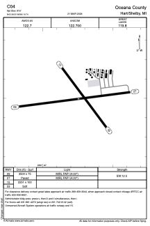


C04 - Oceana County
Located in Hart/Shelby, United States
ICAO - C04, IATA -
Data provided by AirmateGeneral information
Coordinates: N43°38'30" W86°19'45"
Elevation is 916 feet MSL.
Magnetic variation is -05° East View others Airports in Michigan
Operational data
Special qualification required
Current time UTC:
Current local time:
Weather at : KFFX - Fremont Muni ( 35 km )
METAR: KFFX 020135Z AUTO 36005KT 10SM CLR 14/06 A2995 RMK AO2 T01400063
Communications frequencies: [VIEW]
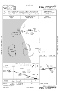
Runways:
| RWY identifier | QFU | Length (ft) | Width (ft) | Surface | LDA (ft) |
| 09 | 83° | 3500 | 75 | ASPH | |
| 27 | 263° | 3500 | 75 | ASPH | |
| 15 | 143° | 2251 | 100 | GRASS | |
| 33 | 323° | 2251 | 100 | GRASS |
Airport contact information
Address: Hart/Shelby United States