


AL44 - Moundville
Located in Moundville, United States
ICAO - AL44, IATA -
Data provided by AirmateGeneral information
Coordinates: N32°58'10" W87°38'13"
Elevation is 162 feet MSL.
Magnetic variation is -00° East View others Airports in Alabama
Operational data
Special qualification required
Current time UTC:
Current local time:
Weather at : KTCL - Tuscaloosa Ntl ( 28 km )
METAR: KTCL 040453Z AUTO 00000KT 10SM BKN110 21/19 A2998 RMK AO2 SLP150 T02060194
TAF: KTCL 032340Z 0400/0424 VRB04KT P6SM VCSH SCT035 BKN070 OVC100 TEMPO 0400/0404 6SM SHRA BR BKN035 OVC070 FM040900 00000KT 6SM BR OVC060 FM041200 00000KT 6SM BR OVC017 FM041500 VRB03KT P6SM BKN028 FM041700 VRB04KT P6SM BKN040
Communications frequencies: [VIEW]
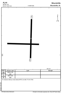
Runways:
| RWY identifier | QFU | Length (ft) | Width (ft) | Surface | LDA (ft) |
| 09 | 0° | 2053 | 100 | GRASS | |
| 27 | 0° | 2053 | 100 | GRASS | |
| 18 | 182° | 2400 | 80 | GRASS | |
| 36 | 2° | 2400 | 80 | GRASS |
Airport contact information
Address: Moundville United States