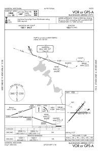


87Y - Blackhawk Airfield
Located in Madison, United States
ICAO - 87Y, IATA -
Data provided by AirmateGeneral information
Coordinates: N43°6'17" W89°11'7"
Elevation is 920 feet MSL.
Magnetic variation is -03° East View others Airports in Wisconsin
Operational data
Special qualification required
Current time UTC:
Current local time:
Weather at : KMSN - Dane County Rgnl/Truax Fld ( 13 km )
METAR: KMSN 041753Z 16013KT 10SM FEW036 BKN190 22/14 A2984 RMK AO2 SLP102 T02220139 10222 20106 58032
TAF: KMSN 041734Z 0418/0518 20010G20KT P6SM SCT045 BKN070 FM042000 26012G20KT 5SM -SHRA BR VCTS SCT010 BKN026CB TEMPO 0421/0423 3SM -TSRA BKN010CB OVC026 FM050000 31012KT P6SM BKN012 OVC022 FM050400 33009KT P6SM FEW030 SCT040
Communications frequencies: [VIEW]
Runways:
| RWY identifier | QFU | Length (ft) | Width (ft) | Surface | LDA (ft) |
| 04 | 40° | 2814 | 57 | ASPH | |
| 22 | 220° | 2814 | 57 | ASPH | |
| 09 | 89° | 2203 | 56 | ASPH | |
| 27 | 270° | 2203 | 56 | ASPH |
Airport contact information
Address: Madison United States