


81D - Flyin Tiger
Located in Angleton, United States
ICAO - 81D, IATA -
Data provided by AirmateGeneral information
Coordinates: N29°15'54" W95°24'45"
Elevation is 30 feet MSL.
Magnetic variation is 06° East View others Airports in Texas
Operational data
Special qualification required
Current time UTC:
Current local time:
Weather at : KLBX - Texas Gulf Coast Rgnl ( 18 km )
METAR: KLBX 300153Z AUTO 11004KT 10SM OVC015 22/21 A2990 RMK AO2 SLP124 T02220206
TAF: KLBX 300120Z 3001/3024 13007KT P6SM BKN014 FM300700 VRB03KT 4SM BR SCT005 BKN015 FM301000 VRB04KT 3SM BR BKN005 BKN012 FM301500 12006KT P6SM BKN015 FM301800 13008KT P6SM SCT030
Communications frequencies: [VIEW]
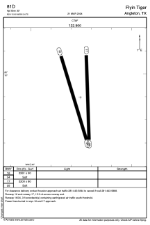
Runways:
| RWY identifier | QFU | Length (ft) | Width (ft) | Surface | LDA (ft) |
| 16 | 163° | 2261 | 90 | GRASS | |
| 34 | 343° | 2261 | 90 | GRASS | |
| 17 | 178° | 2200 | 80 | GRASS | |
| 35 | 358° | 2200 | 80 | GRASS |
Airport contact information
Address: Angleton United States