


7N4 - Honey Acres
Located in Clinton, United States
ICAO - 7N4, IATA -
Data provided by AirmateGeneral information
Coordinates: N42°4'40" W83°59'10"
Elevation is 825 feet MSL.
Magnetic variation is -04° East View others Airports in Michigan
Operational data
Special qualification required
Current time UTC:
Current local time:
Weather at : KADG - Lenawee County ( 25 km )
METAR: KADG 270253Z AUTO 10004KT 10SM BKN095 OVC110 11/07 A3009 RMK AO2 RAB22E51 SLP192 P0003 60004 T01060067 55013
Communications frequencies: [VIEW]
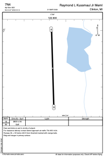
Runways:
| RWY identifier | QFU | Length (ft) | Width (ft) | Surface | LDA (ft) |
| 18 | 178° | 3800 | 90 | GRASS | |
| 36 | 358° | 3800 | 90 | GRASS |
Airport contact information
Address: Clinton United States