


5B1 - John H Boylan State (Island Pond)
Located in Island Pond, United States
ICAO - 5B1, IATA -
Data provided by AirmateGeneral information
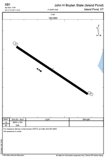
Coordinates: N44°47'24" W71°49'35"
Elevation is 1194 feet MSL.
Magnetic variation is -17° East View others Airports in Vermont
Operational data
Special qualification required
Current time UTC:
Current local time:
Weather at : KCDA - Caledonia County ( 29 km )
METAR: KCDA 260455Z AUTO 00000KT 10SM CLR M02/M09 A3040 RMK AO2 T10191092 400741067
Communications frequencies: [VIEW]
Runways:
| RWY identifier | QFU | Length (ft) | Width (ft) | Surface | LDA (ft) |
| 14 | 124° | 2650 | 120 | GRASS | |
| 32 | 304° | 2650 | 120 | GRASS |
Airport contact information
Address: Island Pond United States